Everglades National Park - Welcome
Overview of the Everglades National Park
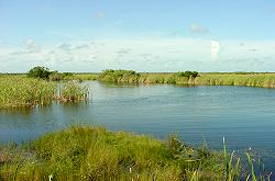
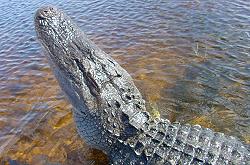
Spanning the southern tip of the Florida peninsula and most of Florida Bay, Everglades National Park is the only subtropical preserve in North America. It contains both temperate and tropical plant communities, including sawgrass prairies, mangrove and cypress swamps, pinelands, and hardwood hammocks, as well as marine and estuarine environments. The park is known for its rich bird life, particularly large wading birds, such as the roseate spoonbill, wood stork, great blue heron and a variety of egrets. It is also the only place in the world where alligators and crocodiles exist side by side.
Everglades National Park has been designated a World Heritage Site, an International Biosphere Reserve, and a Wetland of International Importance. Everglades National Park preserves and protects over 1.6 million acres of some of the best and most complete examples of the natural and cultural history of South Florida. Everglades National Park has three entrances on the Everglades Trail - wonderful opportunities are available at each entrance including boat rides at the western entrance, a tram to an observation tower at Shark River Valley Loop Road, and a series of interpretive features along the road to Flamingo - ending at Florida Bay.
Everglades National Park - Gulf Coast Visitor Center
Gulf Coast is the gateway for exploring the Ten Thousand Islands, a maze of mangrove islands and waterways that extends south to Flamingo and Florida Bay. Canoes may be rented to explore Chokoloskee Bay and the Turner River. For the more adventurous, the 99 mile (159 km)Wilderness Waterway, accessible by canoe, kayak, or small motorboat, winds through the mangrove islands all the way to Flamingo. Backcountry permits are required for camping.
The Gulf Coast Visitor Center is located in Everglades City, in the northwest corner of the park. The visitor center has natural history exhibits, park information, and issues backcountry permits and park passes. It is open daily from 7:30 a.m. to 5:00 p.m. November to April, and 8:30 a.m. to 5:00 p.m. May to November.
Gulf Coast is the gateway for exploring the Ten Thousand Islands, a maze of mangrove islands and waterways that extends south to Flamingo and Florida Bay. Manatees (Trichechus manatus), dolphins (Tursiops truncatus), and osprey (Pandion haliaetus) coexist in this saltwater portion of the Everglades. A 1 hour 45 minute narrated boat trip provides an overall description of this saltwater ecosystem. Canoes may be rented to explore Chokoloskee Bay and the Turner River. For the more adventurous, the 99 mile (159 km) Wilderness Waterway, accessible by canoe, kayak, or small motorboat, winds through the mangrove islands all the way to Flamingo. Nautical charts are recommended, and backcountry permits are required for camping. From the Naples area, take U.S. 41 east and turn south on U.S. 29.
Everglades National Park -Campgrounds
Flamingo Campground
Located at the end of the main park road in Flamingo. It has 234 drive-in sites (55 with a view of the water and 4 group sites) and 44 walk-up sites (20 on the water's edge and 4 group sites). It also provides cold water showers, two dump stations, picnic tables, grills, and an amphitheater for winter programs. There is an observation platform at Eco Pond, adjacent to the campground area. Flamingo has several hiking trails and canoe trails, and opportunities for saltwater fishing are plentiful. Limited groceries and camping supplies are available at the Flamingo Marina store. For More Information on this campground please call 305-242-7700.
Long Pine Key Campground
Located seven miles (11 km) from the main entrance, just off the main road. It has 108 drive up sites for tents and RVs, including one group site. There are rest rooms, water, telephones, and a sewer dump station with fresh water fill, but no showers or hookups. A picnic area is nearby, with fire grates and rest rooms. There is also a pond for fishing, an amphitheater for winter programs, and several hiking trails in the area. For More Information on this campground please call 305-242-7700. To obtain maps, and more information click on the "Visit our Website" button at the top of the page.
Everglades National Park - General Information
- The Gulf Coast Visitor Center is located in Everglades City, in the northwest corner of the park.
- A 1 hour 45 minute narrated boat trip provides an overall description of this saltwater ecosystem.
Available Facilities
Gulf Coast is the gateway for exploring the Ten Thousand Islands, a maze of mangrove islands and waterways that extends south to Flamingo and Florida Bay. Canoes may be rented to explore Chokoloskee Bay and the Turner River. For the more adventurous, the 99 mile (159 km)Wilderness Waterway, accessible by canoe, kayak, or small motorboat, winds through the mangrove islands all the way to Flamingo. Backcountry permits are required for camping.
Everglades National Park - History
Early Development
Water in South Florida once flowed freely from the Kissimmee River to Lake Okeechobee and southward over low-lying lands to the estuaries of Biscayne Bay, the Ten Thousand Islands, and Florida Bay. This shallow, slow-moving sheet of water covered almost 11,000 square miles, creating a mosaic of ponds, sloughs, sawgrass marshes, hardwood hammock, and forested uplands. For thousands of years this intricate system evolved into a finely balanced ecosystem that formed the biological infrastructure for the southern half of the state.
Early colonial settlers and land developers viewed the Everglades as a worthless swamp in need of reclamation. The dream of draining the swampland took hold in the first half of the 1800s. By the 1880s developers started digging drainage canals, which took place without an understanding of the dynamics of the ecosystem and were generally inadequate for the task. They caused localized silting problems, but overall the ecosystem was resilient enough to sustain itself.
The notion of draining the vast wetland persisted. Expanded dredging efforts between 1905 and 1910 transformed large tracts from wetland to agricultural land. This abundance of "new" land stimulated the first of several South Florida land booms. Railroads constructed by entrepreneurs like Henry B. Plant and Henry M. Flagler made the region more accessible and attractive to tourists. By the 1920s visitors and new residents flocked to blossoming towns like Fort Lauderdale, Miami, and Fort Myers. As they arrived, developers cut more canals and built new roads. To ensure good ocean views, they removed mangroves from the shorelines and replaced them with palm trees. Little by little canals, roads, and buildings displaced native habitats.
The year 1948 marked an even greater change when Congress authorized the Central and South Florida Project. This involved the construction of an elaborate system of roads, canals, levees, and water-control structures stretching throughout South Florida. Constructed by the Army Corps of Engineers, and sponsored by the Central and Southern Flood Control District (later redesignated the South Florida Water Management District), the project purposes were to provide water and flood protection for urban and agricultural lands, a water supply for Everglades National Park, the preservation of fish and wildlife habitat, facilitate navigation and recreation, and the prevention of salt water intrusion. While the project still provides many of the intended benefits, the alteration of regional wetland areas, estuaries, and bays � combined with increasing population pressures and changing land uses � has significantly degraded the natural system.
Today 50% of South Florida�s original wetland areas no longer exist. The numbers of wading birds, such as egrets, herons, and ibises, have been reduced by 90%. Entire populations of animals, including the manatee, the Cape Sable seaside sparrow, the Miami blackheaded snake, the wood stork, and the Florida panther, are at risk of disappearing. Exotic pest plants such as melaleuca, Brazilian pepper, and Australian pine have invaded natural areas, choking out native plants and altering habitats. Massive die-offs of seagrass beds in Florida Bay have been followed by the extensive losses of wading birds, fish, shrimp, sponges, and mangroves. These grim indicators warn of a system under assault and in jeopardy of collapse.
The End of the Road
At the end of the nineteenth century the south Florida coast was still largely wilderness, one of the last coastal regions east of the Mississippi to be settled. Only three small communities -- Chokoloskee, Cape Sable and Flamingo -- existed along the coast of what is now Everglades National Park.
Early mariners knew about Cape Sable, located west of Flamingo as it appeared on their maps. It was here in 1838 that Dr. Henry Perrine was given a grant of land. Unfortunately his plans for a settlement did not materialize due to his untimely death at the hands of Indians. Another plan for settlement was proposed by Surgeon General Thomas Lawson who explored the Cape in 1838 for the U.S. government. He built Fort Poinsett on Cape Sable. In 1856 during the Third Seminole War, Fort Cross was established at Middle Cape.
The town of Flamingo was established in 1893; its citizens had to choose a name in order to obtain a post office. According to records from the National Archives, Howell C. Low was the first postmaster. He was appointed on December 13, 1893. Cape Sable had its own post office and Jay L. Watrons was appointed postmaster on February 23, 1904.
The 1910 federal census record shows 49 people living in Flamingo and Cape Sable. Most listed their profession as farming. There were ten heads of households, with 18 children and seven servants. Five people were cane farmers and one worked in charcoal making. (Charcoal was sold in 100 pound sacks at Key West.) Jobs that other individuals held were boatmen, farmer, hauling cane, cane farming (13) and one was retired. We also know from tradition that many, if not all, fished for cash and food. Most also hunted. At the turn of the century plume hunting was a major source of cash income.
Chokoloskee, near present-day Everglades City, was first settled in the 1870s, although it had been the home of Calusa Indians for centuries in pre-Columbian times. It became the trade center for homesteaders scattered throughout the Ten Thousand Islands region.
Charles McKinney was Chokoloskee's first postmaster; he was commissioned on June 30, 1892. George Storter was commissioned as postmaster for Everglades on July 19, 1893.
The 1910 census for Everglades township, including Chokoloskee Island, listed 144 people in 29 different households. Many were farmers or farm laborers. Of those, most were probably engaged in the labor-intensive growing of sugar cane. There was also one carpenter, a mail carrier, a wash woman, a sailor, and a school teacher.
Two men made their livings as merchants, Charles "Ted" Smallwood and George Storter. The largest family, their name illegible in the records, had twelve members.
The Everglade and Chokoloskee community was just recovering from a hurricane in 1909 when it was devastated by another, the worst on record, the following year. Only the highest ground of the old Calusa shell mound remained above water. Low-lying farm fields were salted by flood tides and most cisterns were polluted, a major tragedy in an area where few springs or wells existed. Many inhabitants of the outlying islands were forced to abandon their homesteads. The most infamous incident of the times, the vigilante murder of a local man suspected of several murders, occurred a few days after the hurricane. A somewhat fictionalized account of the event is told in the book Killing Mister Watson by Peter Matthiesson.
In the early days the only way to arrive at Flamingo or Chokoloskee was by boat. Supplies were shipped from Key West, Fort Meyers or Tampa and cane syrup, fish, and produce were traded in return. Although neither town was ever to become a metropolis, they did have commerce, with some vegetables from Chokoloskee even reaching New York City.
When Royal Palm state park was created in 1916, a road was built from Florida City to Royal Palm hammock. The Ingraham Highway, as it was eventually named, was later completed to Flamingo. The name highway gave more prominence to this road than it actually deserved. Often it could only be traveled in good weather and it was always full of ruts and mud holes. Early visitors could however enjoy the scenic Everglades as they traveled this road.
Prosperity of a sort reached Everglades in the 1920s when Barron Collier made it his headquarters for the building of the Tamiami Trail across south Florida. It served as the county seat of Collier County until 1960, when prosperity waned and county offices were moved to Naples. Neighboring Chokoloskee did not have a road until a causeway was built from the mainland in 1956.
Flamingo, still marking the end of the main park road, is now a park community with a campground, ranger station, marina and lodge. Chokoloskee, surrounded by park waters at the end of highway 29, is still home to fishermen, with a few motels and a resort having been added for park visitors. Although the tiny cane farms and fishing shanties are gone, both areas maintain the tranquil beauty for which they are famous.
Information courtesy National Park Service |